 Pitch & Pack
Quick answer
The Garmin inReach Mini 3 Plus is our top pick for most hikers. It weighs just 0.269 lb and offers satellite SOS and messaging via the Iridium network. If you need a dedicated handheld navigator with detailed maps, the Garmin eTrex Touch 010-02940-00 is a strong alternative.
Our top picks
 Best overall
Garmin inReach Mini 3 Plus
Day hikes and ultralight backpacking
 #2 pick
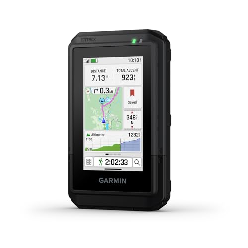
Garmin eTrex Touch 010-02940-00
Multi-day backpacking with map navigation
 #3 pick
Garmin eTrex SE 010-02734-00
Budget-conscious hikers and geocachers
 #4 pick
Garmin inReach Mini 2 010-02602-00
Remote backpacking with basic navigation
 #5 pick
Garmin Montana 760i
Overlanding and multi-activity adventures
On this page
A reliable GPS can make the difference between a confident hike and a stressful one. Whether you are navigating remote trails, tracking your route, or staying in touch with family, the right device depends on how you hike. We compared the specifications of five leading Garmin models to help you choose. Our picks are based on published specs for weight, water resistance, battery life, and satellite capabilities. This guide covers everything from lightweight satellite communicators to rugged handhelds with topo maps.
Comparison at a glance
| Model | Weight | Water Resistance | Link |
|---|---|---|---|
|
010-03387-10
|
0.269 lb | waterproof | View on Amazon |
|
010-02940-00
|
0.331 lb | waterproof | View on Amazon |
|
010-02734-00
|
0.344 lb | water-resistant | View on Amazon |
|
010-02602-00
|
0.6 lb | water-resistant | View on Amazon |
|
010-02964-10
|
0.906 lb | water-resistant | View on Amazon |
Best for: Day hikes and ultralight backpacking
The Garmin inReach Mini 3 Plus is a lightweight satellite communicator that fits in the palm of your hand. At 0.269 lb, it is the lightest device in this lineup, making it ideal for day hikers and ultralight backpackers. It uses the global Iridium network for two-way messaging and interactive SOS, so you can stay connected beyond cell service. The color touchscreen and waterproof rating add durability. On paper, it trades detailed mapping for portability and emergency communication.
Pros
- Lightest model at 0.269 lb
- Global satellite SOS and messaging
- Color touchscreen with IP67 rating
Cons
- Requires active satellite subscription
- No preloaded topographic maps
- Small screen for map viewing
Best for: Multi-day backpacking with map navigation
The Garmin eTrex Touch 010-02940-00 is a dedicated handheld GPS with a bright color touchscreen and preloaded maps for roads and trails. It weighs 0.331 lb and supports multi-band GPS for accurate positioning in challenging terrain. Battery life reaches up to 130 hours in standard mode and 650 hours in expedition mode. The waterproof rating means it can handle rain and splashes. This model suits hikers who want detailed navigation without satellite messaging.
Pros
- Preloaded topographic and road maps
- Multi-band GPS for accuracy
- Long battery life in expedition mode
Cons
- Heavier than satellite-only models
- No satellite SOS or messaging
- Touchscreen can be less responsive in rain
Best for: Budget-conscious hikers and geocachers
The Garmin eTrex SE 010-02734-00 is a budget-friendly handheld GPS with a water-resistant design and a sunlight-readable display. It weighs 0.344 lb and runs on two AA batteries, offering up to 168 hours in standard mode and 1,800 hours in expedition mode. Multi-GNSS support gives access to GPS, GLONASS, Galileo, and more. It pairs with the Garmin Explore app for trip planning and smart notifications. This is a solid choice for hikers who want reliable navigation without a subscription.
Pros
- Excellent battery life with AA batteries
- Sunlight-readable display
- Multi-GNSS satellite support
Cons
- No satellite SOS or messaging
- Smaller screen than the eTrex Touch
- AA batteries not included
Best for: Remote backpacking with basic navigation
The Garmin inReach Mini 2 010-02602-00 is a compact satellite communicator that enables two-way messaging and interactive SOS globally. It weighs 0.6 lb and is water-resistant, making it a rugged companion for remote trips. It includes TracBack routing and a digital compass for basic navigation. When paired with the Garmin Explore app, you can plan trips and view topo maps on your phone. This model is a step down from the Mini 3 Plus in screen and features but still offers reliable satellite connectivity.
Pros
- Global satellite SOS and messaging
- TracBack routing and digital compass
- Pairs with Garmin Explore app
Cons
- Requires active satellite subscription
- No color touchscreen
- Heavier than the Mini 3 Plus
Best for: Overlanding and multi-activity adventures
The Garmin Montana 760i is a rugged handheld GPS navigator with built-in inReach satellite technology and an 8-megapixel camera. It weighs 0.906 lb, making it the heaviest model here, but it packs the most features. It includes TopoActive and City Navigator maps, plus MIL-STD 810 durability and water-resistant rating. The large glove-friendly touchscreen is great for on-road and off-road use. This device suits adventurers who want an all-in-one navigation, communication, and camera tool.
Pros
- Large glove-friendly touchscreen
- Built-in satellite SOS and messaging
- 8-megapixel camera with geotagging
Cons
- Heaviest model at 0.906 lb
- Requires active satellite subscription
- Bulky for day hikes
How to choose
Satellite communicator vs. handheld GPS
The first decision is whether you need satellite communication. A satellite communicator like the Garmin inReach Mini 3 Plus lets you send messages and trigger an SOS from anywhere with a clear view of the sky. This requires an active subscription. A handheld GPS like the Garmin eTrex Touch 010-02940-00 gives you detailed maps and navigation without a subscription but cannot send messages. If you hike in areas with cell service, a handheld GPS may be enough. For remote backcountry trips, a satellite communicator adds a critical safety net.
Weight and portability
Weight matters more on long hikes. The lightest device, the Garmin inReach Mini 3 Plus, weighs 0.269 lb and fits easily in a pocket. Heavier models like the Garmin Montana 760i at 0.906 lb offer larger screens and more features but add noticeable bulk. For day hikes, a few extra ounces may not matter. For multi-day backpacking, every ounce counts. Consider how you will carry the device: in a pocket, on a shoulder strap, or in your pack.
Battery life and power source
Battery life varies widely. The Garmin eTrex SE 010-02734-00 offers up to 1,800 hours in expedition mode using AA batteries, which you can replace on the trail. The Garmin inReach Mini 3 Plus runs on a rechargeable battery and lasts up to 350 hours in tracking mode. If you are on a long trip without power access, a device with replaceable batteries or a very long rechargeable life is better. Check whether the device uses a standard USB-C cable or a proprietary charger.
Map detail and screen size
If you rely on maps for navigation, screen size and preloaded content matter. The Garmin eTrex Touch 010-02940-00 has a color touchscreen with preloaded topographic maps. The Garmin Montana 760i has a large touchscreen with TopoActive and City Navigator maps. Smaller devices like the Garmin eTrex SE 010-02734-00 have a compact display and rely on the Garmin Explore app for detailed maps. A larger screen makes it easier to see terrain contours and waypoints at a glance.
Water resistance and durability
Hiking in rain or near water requires a device that can handle moisture. The Garmin inReach Mini 3 Plus and Garmin eTrex Touch 010-02940-00 are rated waterproof, meaning they can be submerged briefly. The Garmin eTrex SE 010-02734-00 is water-resistant, which handles splashes but not immersion. The Garmin Montana 760i meets MIL-STD 810 for shock and vibration. Choose a higher water resistance rating if you hike in wet conditions or near rivers and lakes.
Frequently asked questions
Do I need a subscription for a hiking GPS?
Only satellite communicators like the Garmin inReach Mini 3 Plus and Garmin inReach Mini 2 010-02602-00 require an active subscription for two-way messaging and SOS. Handheld GPS units like the Garmin eTrex Touch 010-02940-00 and Garmin eTrex SE 010-02734-00 work without any subscription. Check the manufacturer's plan options before buying a satellite device.
Can I use a hiking GPS without cell service?
Yes. Handheld GPS units receive signals from satellites and do not need cell towers. Satellite communicators also work independently of cell networks. Both types function in remote areas where your phone would have no signal.
What is the difference between GPS and GNSS?
GPS is the US satellite system. GNSS (Global Navigation Satellite System) includes GPS plus other systems like GLONASS (Russia), Galileo (Europe), and BeiDou (China). Devices with multi-GNSS support, such as the Garmin eTrex SE 010-02734-00, can lock onto more satellites for better accuracy in canyons or dense forests.
How long does the battery last on a hiking GPS?
Battery life depends on the model and usage. The Garmin eTrex SE 010-02734-00 lasts up to 168 hours in standard mode and 1,800 hours in expedition mode with AA batteries. The Garmin eTrex Touch 010-02940-00 offers up to 130 hours in standard mode. Satellite communicators like the Garmin inReach Mini 3 Plus last up to 350 hours in tracking mode. Always check the manufacturer's estimates for your expected use.
Can I use a hiking GPS for driving directions?
Some models include road maps. The Garmin Montana 760i comes with City Navigator maps for on-road navigation. Most handheld GPS units are designed for off-road use and may not provide turn-by-turn driving directions. For car navigation, a dedicated automotive GPS or phone app is usually better.
Bottom line
For most hikers, the Garmin inReach Mini 3 Plus offers the best balance of weight, safety, and connectivity. If you need detailed maps and longer battery life for multi-day trips, the Garmin eTrex Touch 010-02940-00 is a strong choice. Budget-conscious hikers will appreciate the Garmin eTrex SE 010-02734-00, while those who want an all-in-one adventure tool should consider the Garmin Montana 760i.
Related articles
-
Best Trowel for Backpacking
Find the best trowel for backpacking. We compare specs like weight and material to help you choose a lightweight, durable cathole tool for the trail.
Nov 9, 2026
-
Best Sit Pad for Hiking
Find the best sit pad for hiking. We compared specs like weight and water resistance to help you choose a comfortable, packable seat for the trail.
Nov 9, 2026
-
Best Hiking Umbrella
Find the best hiking umbrella for your next trip. Compare top picks based on weight, coverage, and hands-free features. Choose the right umbrella for day hikes and backpacking.
Nov 9, 2026
-
Best Gaiters for Hiking
Find the best gaiters for hiking. We compare specs like weight and water resistance to help you choose the right pair for day hikes, backpacking, and wet conditions.
Nov 9, 2026